Typically, what the local government really wants is not the ‘raw’ Lidar data, but all Lidar returns further down the processing line. Commercial tools to process ‘raw’ Lidar imagery are not easy to use, nor are they currently cost effective. ERDAS, the inventor of commercial remote sensing, has historically been the company to introduce cost-effective remote sensing tools into the market-place. (I see Lidar as a remote sensing tool that heretofore has been used most successfully by photogrammetrists.)
It is understandable that local governments want more than detailed terrain model from their Lidar collection. Heretofore, Lidar collections have centered on elevation, but there is much more value available in Lidar data than only an elevation model. It is my belief, to use Lidar only as an elevation source, is like using imagery only as a backdrop to a GIS vector dataset; valuable, but very wasteful of the tax payer’s money.
Local governments need more value from their Lidar collections than just elevation, but that value is not easily captured in the ‘raw’ data. What Lidar data do local governments need to request? They need Lidar data that has been bore-sighted. Bore-sighting removes the small imprecision found in the GPS and IMU. These errors can be quite significant errors at a flying height of 5,000 feet (1500m).
After bore-sighting, the data are edited to define ground points and other features. This is a needed step to prepare the point cloud for terrain purposes. Yet, the Editing process can introduce very valuable information. Here is where vendor can classify the points into categories. The philosophy that points should be flagged with a classification, rather than be deleted from the dataset, emerged during the development of the LAS data format standard.
It is my opinion; the local government should obtain the intermediate product at this stage. All returns, bore-sighted and classified, no points added or removed. And, a full QA/QC report. If it were me, I’d ask for the intensity information as well.
The final need, the LAS tiles should each have fully defined horizontal and vertical coordinate systems (as ASPRS suggests). So many times local governments accept LAS tiles that only have the horizontal datum defined. Without knowing the vertical datum, you do not really know the height. Also, putting the vertical datum inside the LAS file rather than on a yellow sticky note on the DVD is far more appropriate. (And what happens when the yellow sticky note looses its sticky?)
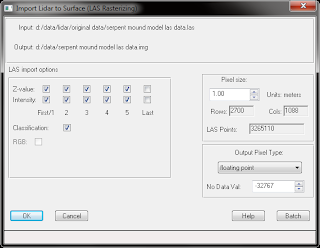
Local governments ask, what can I use to work with my Lidar data? I said earlier, “Commercial tools to process ‘raw’ Lidar imagery are not easy to use, nor are they currently cost effective. ERDAS, the inventor of commercial remote sensing, has historically been the company to introduce cost-effective remote sensing tools into the market-place.” Now, ERDAS is presenting tools to convert your Lidar data to raster for further processing.
But why raster?
- Raster conversion of the point cloud can shrink LAS file to a IMG file ¼ the file size of the LAS (you only store x & y values once in the raster UL corner). But that is not the main reason, as I suggest keeping the LAS files in backup for the day when point processing engines are cost effective.
- The files being converted into raster allows a visual QA/QC of the data.
- Open Lidar collections up to the ERDAS community in a very cost effective manner (no additional costs). Once the data are in raster, the Spatial Modeler, Model Maker, Classification, Expert Classification, and Objective are available to the customer to process the data.